
- » QL-A Test Hole Service
- » QL-B Utility Designating
- » System Mapping & Data Management
- » Ground Penetrating Radar (GPR) Locating
- » Utility Coordination
- » Utility Design
- » GIS Mapping
- » Video Pipe Inspection
System Mapping and Data Management:
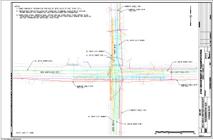
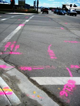
At SUE Solutions, we place a strong emphasis on the mapping side of the SUE process. We recognize that the improved technologies and expanding utility demands have resulted in an extremely complex underground network. SUE Solutions currently uses the latest technology in global positioning system (GPS), geographic information system (GIS), and traditional total station surveying methods. Without accurate and easily retrievable utility data, the expenditure made to determine a utility's location is a mute effort. SUE Solutions offers subsurface utility engineering that can accurately determine the precise horizontal and vertical location of underground utilities. Using computer-assisted design (CAD) or geographic information system (GIS) technology, our subsurface utility mapping provides a user-friendly, flexible method for analyzing and applying the information generated by SUE. It allows designers and planners to more fully examine project options and plan ahead to reduce or eliminate utility conflicts earlier in the life of the project.
While SUE provides straightforward utility location information, our mapping provides multiple levels of sophisticated and therefore much more descriptive information about underground utilities. With our subsurface utility mapping, it is possible to track an existing utility from its point of origin to its destination, provide the best routing for the new utility line or new roadway feature, and show any specifics that are pertinent to the location effort. Subsurface utility mapping also offers information on the type of utility and ownership. We also strictly adhere to DOT CADD/Survey standards in the formulation of standardized mapping files. Additionally, SUE Solutions incorporates systematic reviews of data collection and mapping materials by independent I qualified reviewers to ensure the competency and accuracy of the data.
Some areas where SUE Solutions survey and mapping services have been used is within the following applications:
- Project Design Survey and Mapping (QL-B & QL-A)
- Utility As-Builts
- Utility Facility Inventory
As part of our complete data management services, we also offer customized software applications such as Micro Utility Viewer © that allows for streamlined data development and fingertip access of all utility and SUE data directly inside Microstation.